Looking for the Guilford Quaker burial ground….
I had decided to see what I could find out about the early generations of my TRUITT ancestors, and perhaps find some of the old graves, since I'm in Somerset County MD. My research led me to information concerning the Quakers and the early meetings that the Truitts, especially George, were involved in. The Guilford (Muddy Creek) Quaker Meeting House and burial ground on 1 acre of land in land patent plot A112 (the extreme northwest corner) became a focus, but it appeared that nobody knew exactly where it was.
I was an intelligence specialist in my days in the Air Force. I tapped those skills to try to plot out on a map just where the site might be, based on descriptions in Whitelaw's book, Dr. William Groves’ work, and a map plot of the original land patents on the GHOTES site. I then went to Guilford and started looking.
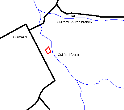
I'm almost certain that I have found the burial ground. It's located almost exactly where it should be by the descriptions. It's in a grove of sassafras trees in a horse pasture, about three-tenths of a mile southeast of Guilford... here's a rough map plot of the location (the area in red):
Here's a link to a larger map of the same area:
There are a number of newer graves in and behind the site with surface-type burial vaults (ie concrete or plaster-like material, none marked) and four older stones (1850-1905 death dates) that seem to lie around the perimeter of a central area where nothing is really visible. As I searched more, I found a burial vault made only of bricks that was partially caved in (the horses go into the area, and probably stepped on it). Bricks were available around here as early as the late 1600's -1700 or so, so it could be that old. But here's where it really got interesting... I found some plain stones just barely peeking up through the dirt. I thought at first that they might be pieces of a headstone that had fallen over, but I prodded around them, and they seemed too small for that. I dug out some of the dirt around them and found two stones right beside each other. They were plain stones with no evidence of writing on them, but there are NO NATURAL STONES in this area, so they had to be placed there. I remembered that many early Quakers did not use "tombstones":
The Quakers resolved against "the vanity and superstition of creating monuments and entombing the dead with singular notes or marks of distinction, which is but worldly pomp and grandeur, for no encomium nor pompous interment can add worth to the deceased". Therefore, they ordered the erection of tombstones over the graves of Friends be stopped, and the tombstones already so placed to be removed. However, this order was not generally obeyed [Scharf:183].
I also remembered that I had read somewhere that some just used plain "field stones" stood up on end to mark that a grave was there. I got very excited at this point!
I looked around some more.. I found a stone about 5 feet away that was about 12" across, oval-shaped with a flattened bottom, but no writing, laid over on it's side, just barely out of the dirt. Then about 4 or 5 feet on the other side of the "twin stones", I found a small (about 4" x 4" x 10"), rectangular stone just peeking out. As I dug out around that one, I found it was obviously cut in that shape, with chisel marks visible, but no writing. I found another odd-shaped stone at the base of tree about ten feet further away. I backed away, and looked across the site, and they all lined up in a straight line!
I was only in the site for a few hours, so I didn't find much more, but the plain stones were on the edge of that large area that looks plain... I'm fairly certain there's more there. I think the horses may have done some damage.. I saw at least one more hollow spot where a vault must have collapsed near the other brick vault, but everything I have described formed kind of a right-angle perimeter around the plain area in the center of the grove. I don't know how close to the meeting house the burial ground might have been. It’s possible that the right-angle might have wrapped around a building or perhaps the oldest burial area, containing unmarked graves.
I shot about 40 pictures in there, including some good ones of some of the plain stones. Many of them are available on the GHOTES Virtual Cemetery site.
The unfortunate thing about the visible marked stones is that the names don't seem to link up to Quakers that I can find yet ...Onions, Beasley (her mother was an Onions), and Wessels. They were all family names of people who had lived in that immediate area. Perhaps subsequent owners just continued to use the burial ground, since they owned the land.
The current owners didn't know much about it, except that there were some graves back in the trees. I plan to share what I have found with them.
Jim Crouch
Somerset County, MD
Back to Quaker (Onions) Cemetery
 >>> Advertise Here <<<