2:37 am EDT Jul 19, 2026

T-STORMS?
|
| Hi: 88 F, 31 C
|
Lo: 74 F, 23 C
| A chance of showers and thunderstorms. mainly between 2pm and 5pm
Winds N 10 |
|
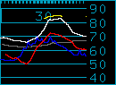
Barometric pressure is 29.81
Winds are from the west at 13 knots
Chesapeake Bay temperature is 83
Sunrise 5:57 AM, sunset 8:22 PM
The Moon is Waxing Crescent (28%)
|
Eastern Shore Forecast as of 2:37 am EDT Jul 19, 2026
Sunday: A chance of showers and thunderstorms. mainly between 2pm and 5pm. Partly sunny, with a high near 88. West wind around 10 mph becoming north in the afternoon. Chance of precipitation is 40%. New rainfall amounts of less than a tenth of an inch. except higher amounts possible in thunderstorms.
Sunday Night: A chance of showers and thunderstorms before 3am. then a slight chance of showers after 4am. Mostly cloudy, with a low around 74. East wind around 5 mph becoming calm. Chance of precipitation is 30%. New rainfall amounts of less than a tenth of an inch. except higher amounts possible in thunderstorms.
Monday: Mostly sunny, with a high near 84. East wind 5 to 10 mph.
Monday Night: A chance of showers and thunderstorms. then showers and possibly a thunderstorm after 2am. Low around 75. Southeast wind around 8 mph. Chance of precipitation is 80%. New rainfall amounts of less than a tenth of an inch. except higher amounts possible in thunderstorms.
Tuesday: Showers and possibly a thunderstorm. High near 89. Chance of precipitation is 80%. New rainfall amounts between a tenth and quarter of an inch. except higher amounts possible in thunderstorms.
Tuesday Night: Showers likely and possibly a thunderstorm. Mostly cloudy, with a low around 77. Chance of precipitation is 70%.
Wednesday: Showers likely. then showers and possibly a thunderstorm after 8am. High near 88. Breezy. Chance of precipitation is 80%.
Wednesday Night: Showers and possibly a thunderstorm before 2am. then a chance of showers. Low around 72. Chance of precipitation is 80%.
Thursday: A chance of showers before 2pm. Partly sunny, with a high near 83. Chance of precipitation is 40%.
Thursday Night: Partly cloudy, with a low around 71.
Friday: Mostly sunny, with a high near 83.
Friday Night: Partly cloudy, with a low around 71.
Saturday: Partly sunny, with a high near 84.