
In Lower Accomack County Virginia
From the book "Grave Stones Inscriptions From Lower Accomack County, Virginia" Published in 1987 by Heritage Books,
Inc.
(ISBN 1-55613-042-2)
Compiled by Jean Merritt Mihalyka and Faye Dowing Wilson
With permission from Jean Merritt Mihalyka
This Web Page was Last Updated Friday, October 10, 20023
Note: It is the intent of the Ghotes Webmaster to add links to "MapQuest" from this page to allow the viewer to display a road map to each of the Grave Sites.
Click on the![]() icon next to each entery, where provided, to view a road map close to the grave site.
icon next to each entery, where provided, to view a road map close to the grave site.
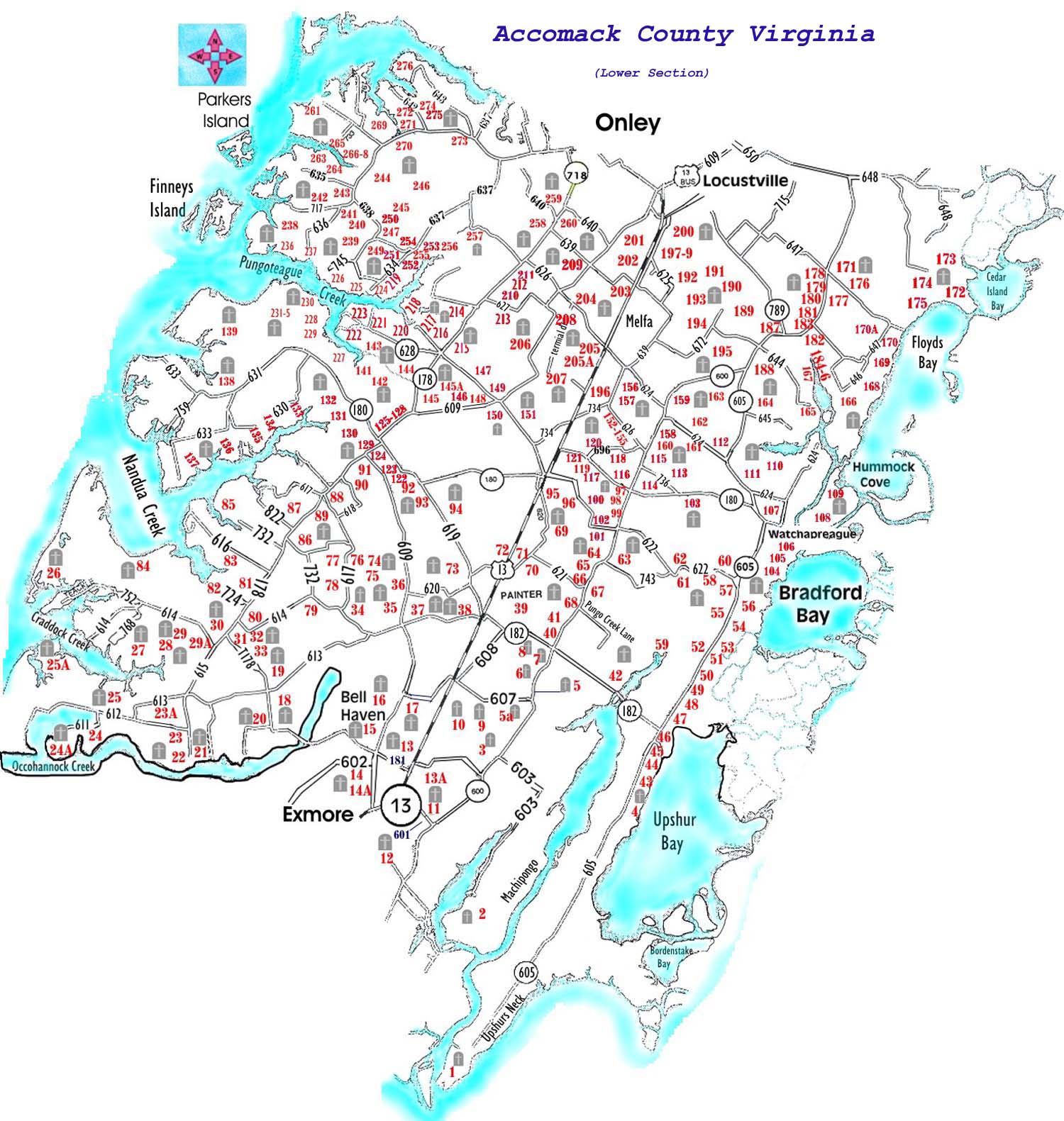
Map 1 of Lower Accomack County Showing Cemetery Location, by number.
Map 2 - Middle Section Accomack County Showing Cemetery Location, by number.
The name of the plot in which the burial'can be found is indicated after each entry in the text. All plots are listed here, having been assigned a number. That number
is used to identify the location of the plot on the accompanying map.
Recorded with each entry are precise directions for finding the site which include the general area in the county, mileages, route numbers. Also for each site are listed the surnames of all families buried in that particular plot. Such is not done, of course, for the large public cemeteries and. churchyards.
![]() Belle Haven Cemetery (inc Feb 1901) ? recorded in Gravestone Inscriptions in Northampton Co., YA, J.M. Mihalyka, comp. Published by VA State
Library, 1980.
Belle Haven Cemetery (inc Feb 1901) ? recorded in Gravestone Inscriptions in Northampton Co., YA, J.M. Mihalyka, comp. Published by VA State
Library, 1980.
![]() 1. White Plot ? in Upshur's Neck, 3.2m. S of R606 in Quinby to the west of R605. Follow farm lane for about .4m. to wooded area along Machipongo Creek. Turn S along creek. Burial site is at least .5m at southern end of field a few yards into woods. (White)
1. White Plot ? in Upshur's Neck, 3.2m. S of R606 in Quinby to the west of R605. Follow farm lane for about .4m. to wooded area along Machipongo Creek. Turn S along creek. Burial site is at least .5m at southern end of field a few yards into woods. (White)
![]() 2. Old Bell plot ? (Bell's Neck) to end of R603; then .5m on farm road toward point. Plot to the W. Once a large burial plot with very old slate markers. (Bell)
2. Old Bell plot ? (Bell's Neck) to end of R603; then .5m on farm road toward point. Plot to the W. Once a large burial plot with very old slate markers. (Bell)
![]() 3. Nock plot ? (Bell's Neck) 2.1m from R600, to the W of R603 in lane for .4m. In field to the right. (Nock)
3. Nock plot ? (Bell's Neck) 2.1m from R600, to the W of R603 in lane for .4m. In field to the right. (Nock)
4. Warwick ? 1m. S of Quinby (junction of R605 & R182), to the E of R605. Two plots; one to the N side of the driveway, one to the S side ? both W of the main house. (Boisnard; Eidelberger; Quinby; Upshur)
5. Coal Kiln ? .1m S of the junction of R607, take dirt road to E off R600 for .4m. Plot is .1m to the N in field. (Dunton; LeCato; Moore; Smith)
5A. Ayres Plot - .4m S of the junction of R607 (Coal Kiln) to the W of R600 beside the road. (Ayres)
6. Bull site ? .5m. S of Mappsburg to the W of R600. No stones remain in clump of trees in middle of field. Ref: 1940 record. (Bull)
7. Powell plot ? .2m S of R182 (Mappsburg), to the W of R600. Well behind house; very overgrown. (Ames; Ashby; Dunton; Jackson; Mapp; Nottingham; Powell)
8. Turner plot ? (Mappsburg) .7m E of R600, to the S of R182; .4m in field (Kellam; Turner)
9. New Mt Zion ? (E of Painter) New Mt Zion African Baptist Church. Est. 1881, rebuilt 1947. 1m E of R13, to the S of R607. Churchyard extends to a new section to the west behind houses (copied April 1982).
10. Sturgis?Painter ? .7m E of R13 near Painter to the S of R607; .1m in field. (Sturgis)
11. Phillips Place ? .2m N of R601, to the E of R600 (just into Accomack Co.), .3m in lane to house. This rather large plot is recorded in Gravestone Inscription in Nor?thampton Co., VA, J.M. Mihalyka, comp. 1980. (Chandler; Dunton; LaCato; Nottingham; Robins)
12. Ayres Lot ? .1m E of R13 to the S of R601. Numerous black burials. (Ayres; Harmon; Robinson; Rogers; Smith; Taylor; Thomas; Williams)
13. Edmonds?Braxton ? to the W of R13 across from junction of R603 (Belle Harven Station). Behind Kellam Distribut?ing Co. office building. Also 6 or more unmarked graves. (Edmonds; Braxton)
13A. Matthews-Wyatt Plot (Belle Haven Station just N of county line) to the E of R13 across RR tracks c.50 yds into woods, .1m S of R603. Once a large family burial ground. (Abdell; Brown; Churn; Matthews; Smith; Turner; Wyatt)
14. Ward family cemetery ? in Belle Haven Town Square at junction of R602 with R178. (Lewis; Ward)
14A. Willis grave ? .1m S of R178, to the E of R602 (Belle Haven Cemetery Rd.). Behind house. Stone is enveloped in the base of large tree. (Willis)
15. Floyd burial ground ? .5m N of Belle Haven (junction of R181 & R178) to the W of R609, .5m in lane to S of shed on slight hill. (Floyd)
16. Old Floyd burial ground ? .5m N of Belle Haven (junction of R181 & R178) to the W of R609. In lane for .8m to woods (passing to the left the Floyd burial ground near shed). Straight back in woods on a knoll. Once many stones; only one located. Old Byrd's Sawmill area. (Floyd)
17. St. Joseph's ? St. Joseph African Methodist Episcopal Church (1920 site). 1.1m N of the center of Belle Haven on R609 at the junction of R607; in the SE corner. This burial ground is poorly kept; many unmarked graves (copied Feb. 1982).
18. Jacob burial ground ? (near Shields) .5m E of R178 to the S of R613 .3m in farm lane to the left in field. (Jacob; Kellam; LeCato; Martin; Wise)
19. Walter grave ? behind site of old stone at Shields (intersection of R613 & R178). Moved to Fairview Lawn. (Walter)
20. Mt. Pleasant ? just W of Occahonnock Creek Bridge on R178, turn S in private lane for .5m. To the right of house beyond the lawn; within brickwall. (Bull; Bradford; Douglas; Duncan; Kellam; Shield)
21. The Glebe ? from R615 into Davis Wharf turn E into lane at top of hill; almost to the Wharf. (Ames; Davis; Goffigon; Mears; Rue)
22. Sturgis plot ? (Scarborough Neck) .2m W of R615 to the S of R612, in private lane for .5m. Plot to the left near lane. (Hutchinson; Sturgis; Mason; Wright)
23. Sturgis burial ground ? (Scarborough Neck) .35m W of R615 to the S of R612; .4rn in dirt lane to the left. In?dications of many unmarked graves in this old
plot. (Ames; Mason; Parkes; Sturgis)
23A. Sample Plot- .5m N of R612 to the W of R615 (Davis Wharf Rd.) (Moore; Sample)
24. Hedra Cottage ? (Scarborough Neck) 1.6m W of R615 from R612, turn S onto R611 for .3m. Take lane to the right for .4m. Plot across field to the right in
heavy thicket. (Custis; Nottingham; Scarborough; Smith)
24A. Bay View (Scarborough Neck) .7m W of R615 on R612, turn left onto hard surfaced road for .4m. Turn right onto lane for .1rn to house. Grave to south.
(Bayne)
25. Hollybrook Farm ? (Scarborough Neck) 1.35m W of R615 to the N of R612; S .5m in lane to NW of house. (Boggs; Bull; Goffigon; Kellam; Royal)
25A. Vale of Shavez- 2.4m W of R615 to the N of R612 (Scarborough Neck Rd.); c. .8m in farm rd. to site of farm house. A recording of the stones ( which have not yet been located) is among the Thos Teackle Upshur Manuscript Collection, Vol.2, pp.401-402 in the Swem Library, College of William and Mary.
His work was done during the first decade of the 1900s. (Coward)
26. Bayberry Farm ? (Craddock Neck) 1.5m W of R615 on R614. Continue due W on hard surface road for .9m to house; then turn E along creek for .2 mile to point. Two plots: Allen is beside woods road; Hyslop is deeper in woods to the S. (Allen; Hyslop; Tawes)
27. Hyslop site ? (Craddock Neck) 1.1m W of R615 to the S of R614. 1m. in farm lane. Graves which were to W of old house near creek in the Hyslop family burial ground were moved in 1936 to Belle Haven Cemetery. See Gravestone Inscriptions in Northampton Co., VA.
28. Kellam burial ground ? (Craddock Neck) 1.1m W of R615 to the S of R614. 1m in farm lane to E in wooded area. (Kellam)
29. Bell grave ? (Craddock Neck) .4m W of R615 to the S of R614 in lane for .6m to the W of field on edge of woods. Other stones bulldozed years ago. (Bell)
29A. Hermitage ? 1.1m W of the intersection with R178 (at Craddockville), turn right off R 165. In dirt road for .9m. Graveyard in field to the left in clump of
trees. (Bailey/ Bayley; Neely)
30. Crad. Meth. ? Craddockville United Methodist Church, built 1871. At junction of R615 with R178N, Craddock?ville. Graveyard behind church building.
(Ayres; Berry; Callahan; Hickman; Killom; Mason; Martin; Smith; Thomas; West; Winder)
31. Crad. Meth.?s ? at junction of R615 with R178N, in Crad?dockville; SE corner. This is the site of Craddockville United Methodist Church from 1850?71.
(Bull; Custus; Guy; Jones; Kellam; LeCato; Lingo; Melson; Parks; Winder; Young)
32. Chandler plot ? (Craddockville) .1m N of the junction of R615 with R178N. On E side of R178N. (Chandler; Colona; Elmore; Mason)
33. Anderson Place ? .5m S of Craddockville on R178S, turn left into lane for .5m. Site well to E of house in a thicket. (Wynder)
34. Experiment Farm ? (W of Painter) .1m from R614, to E of R617 in field. (Ames; Mears)
35. Cutler?Stewart ? (between Middlesex & Shields) .25m W of R609 to the N of R614; .05m. in field. (Cutler; Stewart)
36. Drummond?Doughty ? .2m N of R614 (at Middlesex) to the W of R609. Across field and along the N side of woods; plot is just inside the woods. Evidence
of many graves; only 3 stones found. (Drummond; Doughty)
37. Tipton Farm ? (W of Painter) .2m. N of R614 (at Middlesex) to the E of R609 .1m in lane to left of house .(Tipton; Sturgis)
38. Baily graves ? (W of Painter) .8m. S of R614 (Middlesex) to the E of R609 in farm road for .8m. Across field to the E in woods. Once a very large Black
burial ground. Only 2 marked graves remain. (Baily)
39. Edmonds plot ? (in Painter) in the SE corner of junction of R1202 with R182. (Bell; Edmonds)
40. Garrison plot ? at intersection of R600 & R182 (Mappsburg) on the NW corner in field NW of house.
Numerous unmarked graves. (Thought to be the original site of Garrison's Chapel later moved to Painter). (Bell;
Garrison; Glenn; Goffigon; Harrison)
41. Taylor farm ? (at Mappsburg) .4m N of R182, to the W of R600; .05m. into field. (Bradford; Marston: Nock; Stringer; Taylor)
42. Powell lot ? 1m. E of Mappsburg ( .4m E of the Quinby Bridge) to the N of R182; about .2m in field. (Floyd; Powell)
43. Smith's Chapel site ? .1m from R605 to the S of R606 (between R773 & R748). This was the church graveyard of Smith's Chapel before the church was
moved nearer to the center of Quinby. (Pilchard; Turner)
44. Atlantic View ? (in Quinby) .3m S of junction of R182 on E side of R605. Only I stone remains of the very old & large Bradford Burial Ground which was a
good distance to the east of the old Wm. Bradford home. Stones were pushed into the marsh; a tragic loss. (Bradford)
45. Quinby Cemetery ? .1rn from R605, on R773 in Quinby. This community cemetery is well kept, but does have a good many unmarked graves. In the
southwest corner is the old LeCato burying ground (copied Feb. 1982).
46. LeCato?Bell ? .05m N of Quinby (junction of R182 with R605), to the E of R605 behind house in a field. Once a fairly large burial plot on the Bell property.
Only 1 stone remains. Information supplied by Rooker Powers & Gladys Bayly of Quinby. (Bell; LeCato;.Ward)
47. Old Homestead ? (in Quinby) .1m N of R182 to the E of R605 behind house .1m in hedge row. (Bundick)
48. James burial ground ? .25m N of Quinby (junction of R182 & R605), to the E of R605; .2m in lane to the SE of house. (Barnes; Eickelberger; James)
49. Bradford?Burton ? .6m N of Quinby (junction of R182), to the E of R605. S of house in thicket. (Ashby; Bradford; Burton; Elliott; Kelly; Wallace)
50. Garrison Lot ? 1.2m N of Quinby (junction of R182 with R605), to the E of R605. To the SE of house in field. (Garrison)
51. Thorny Crest ? 1.45m N of Quinby (junction of R182 with R605), to the E of R605. To the SE of house. (Fet?terman; Fleming; Smith)
52. Bell burial ground ? 1.5m S of R622 (Old Trower) to the W of R605. Stones lie flat in grass to the south of house. (Bell; Downing)
53. Bell?Floyd ? 1.8m N of Quinby, to the E of R605. Behind house to the SE. (Bell; Bradford; Floyd; Kellam)
54. Davis Lot ? 2m N of Quinby (junction of R182 with R605), to the E of R605. To the NE of house behind barn. (Davis)
55. George H. Bell burial ground ? 2.4m N of Quinby (junction of R182 with R605), to W of R605 in yard behind small, old house. (Bell; Downing; Edmunds;
Welch)
56. Turlington burial ground ? 2.75m N of Quinby (junction of R182 with R605), to E of R605, .2m in lane. SE of house near marsh. (Bell; Downing; Stockley;
Turlington)
57. Kellam?Bell ? (at Old Trower). SW corner of junction of R622 with R605. To S end of house. (Bell; Bradford; Kellam)
58. Poulson grave ? (at Old Trower) .2m W of R605 to the S side of R622 in woods but close to road. (Poulson)
59. Thomas H. Bell plot ? (at Old Trower) .7m W of R605 to the S of R622, go into woods following old road. Turn E & follow remains of an older road across
marsh (head of Machipongo Creek). Go only at low tide. Upon reaching a wooded spit of land, turn S & walk a good distance. Grave plot is almost to the
point near ruins of old brick house in thick woods. (Bell; Bradford; Marston; Mears; Rose)
60. Fletcher Farm ? Old Trower. 1m W of R605 to the N of R622. Follow farm road at least 1m through woods to ruin of old house. Plot to right side of front
yard. Data for unmarked graves supplied by Hilda H. Powell, Quinby & Mildred B. Nock, Wachapreague from ledger kept by her father, Abel J. Bell,
merchant of Old Trower. (Fletcher; Hickman; Scott)
61. Anthony Bell plot ? (Old Trower). 1m W of R605, to the S of R622; .05m in lane to plot. (Bell; Isdell; Mears)
62. Davis?Mears ? 1.1m W of R605 at Old Trower to the N of R622 beside road. (Davis; Mears; Miller)
63. Stockley plot ? (N of Frogstool) .1m N of R743, to the E of R600 in field. (Coleburn; Stockley)
64. Morrison Hill ? (S of Frogstool) .8m S of R622 to the W of R600. (Davis; Ensor; Fletcher; Floyd; James; Johnson; Mears; Nock; Powell)
65. Savage plot ? (just N of Red Hill) .2m N of R621, W side of R600. This plot & the Wallace plot are in field behind houses, about 100 feet apart. (Christian;
Savage; Sturgis)
66. Wallace plot ? (just N of Red Hill) .2m N of R621, W side of R600. This plot & the Savage plot are in field behind houses, about 100 feet apart. (Wallace)
67. Snead's ? Snead's African Methodist Church; organized 1881. In SW corner of the intersection of R600 & R621. Some graves are across R600 (copied Jan.
1983).
68. Nock burial ground ? (S of Red Hill) .5m S of R621 to the W of R600, .5m in farm road to SW of old house in field. (Nock; Turner)
69. E. T. Downing plot ? (between Painter & Keller) .3m E of R620, to the N of R621; about .4m across field near woods. (Downing; Mathews)
70. Mears graves ? (Ames Ridge N of Painter) .45m E of R13 to the E of R620 in field. (Mears)
71. Ames grave ? .1m N of R620 to the E of R13 (across from Central High School). Part?way in field. (Ames)
72. Ames plot ? (Painter) .4m E of R619 to the N of R620, .2m in lane; plot to left of house. (Ames; Elliott; Taylor)
73. Thoro Mears ? (NW of Painter) .7m N of R620 to the W of R619, .1m in field. Probably more stones covered by heavy thicket. (Ames; Mears)
74. Joynes plot ? (NW of Painter) 1.5m N of R614 to the W of R609; .2m into field. (Joynes; McKowan; Twiford; Young)
75. Ames?Hyslop ? (N of Painter) 1.3m N of R614 to the W of R609, .3m into field. (Ames; Hyslop; Twiford)
76. Doughty plot ? (SE of Pennyville) 1.1 m N of R614, to E side of R617. Behind house. (Doughty; Frost; Guy)
77. Forest Grove ? (SE of Pennyville) 1m N of R614, to the W of R617. At S end of house. (Doughty)
78. Forest Grove?old plot ? (SE of Pennyville) .9m N of R614 to W of R617; .4m of farm lane into field. (Behind the main Forest Grove house.) (Doughty;
Fowler)
79. Lingo plot ? (NW of Experiment Station? Painter) in field in NW corner of the junction of R732 with R614. (Lingo; Mason)
80. Smith's burial ground (black) ? (between Craddockville & Boston) .75m S of R730 to the E of R178; .3m in dirt lane. Plot in NE corner of field beside
woods. Numerous names; also some unmarked.
81. Guinea ? (between Craddockville & Boston) .7m S of R730 to the W of R178 beside road. Black burials; numerous, most unmarked.
82. Maple Dale ? .6m N of Craddockville Church on R178, turn W into R724, .6m to the end of road. Plot to N of old house on edge of creek. Large burial plot; only 2 stones remain. (Kellam)
83. Old West Place ? (N of Craddockville) 1.2m W of R178 to the S of R616, .3m in shell road; plot to N of house. (Also known as Cedar View.) (Gascoyne;
Rowles; West)
84. Major Farm ? (Craddock Neck) 1.5m W of R615 to the N of R614; .7m in dirt lane to the E in woods. (Major)
85. Fairview (Andewey Plantation) ? (near Boston) .2m S of R732E to the W of R178, turn onto R732W. Drive 1.3m to house, behind which is a large shaft
erected in 1929 bearing data "of those buried here & those related". See Whitelaw: 658?60. The compilers are indebted to E. Spencer Wise for a list found in
the "Hack Manuscripts" of the inscriptions on the original tombstones before they were covered over by the newer monument. (Hack; Henry; Kellam; Knight;
Read)
86. Shiloh ? Shiloh Baptist Church; organized 1875. Oldest of the 3 churches named Shiloh (black). 2.4m N of Crad?dockville to E of R178N (copied Dec.
1982).
87. H. Trinity ? Holy Trinity African Baptist Church. Est. 1905. (N of Boston) .3m S of R617 to the W of R178 be?side road. (Copied 1979.)
88. Bull?Pennyville ? .2m E of R178 (Pennyville), to the N of R617. A fairly large plot was destroyed; stones hauled away. One stone's inscription survives.
(Ayres; Bull)
89. Waterfield Farm ? (SE of Pennyville) 1.4m N of R614 to the W of R617; in field about .4m. Also known as the Colonna family burying ground. (Colona;
Doughty; Holt; Jones; Onley; Stewart; Watson)
90. Guy plot ? .9m S of junction of R178 (at Pungoteague) to the W of R609. In wooded area .3m into field. (Downing; Guy; Miles)
91. Sylvan Retreat ? .6m E of intersection with R178 (just SE of Pungoteague), to the S of R609. In farm lane for .4m; plot to W of house in yard. Stones lay flat
partly covered by grass. Also called G.E. Bull Farm. (Andrews; Ker)
92. Walker Farm ? W of Painter at the junction of R619 with R180; SW corner. (Walker)
93. Dix grave ? (NW of Painter) 1.6m N of R620 to the W of R619, .15m in field. One stone dug from 18 inches below surface; others probably buried deeper.
(Dix)
94. Martin plot ? (NW of Painter) 1. 1 m N of R620, to the E of R619 beside road. (Kellam; Martin)
95. West lot ? (S of Keller) .1m from R13 to the S of R620 in field. (West)
96. Savage burial ground ? (E of Keller) .9m S of R696 to the W of R622, .1m in field. (Savage)
97. Bradford?Hyslup ? .1m S of R180 (at Grangeville) to the W of R600; to the N of house in garden. Hyslop plot in same yard. (Bell; Bradford; Drummond;
Hyslup)
98. Hyslop plot ? (Grangeville) .1m S of R180, to the W of R600, in front yard. Bradford?Hyslop plot in same yard in garden to the N side. (Hyslop/Hyslup)
99. Lingo burial ground ? .3m S of R180 (Wachapreague Road at Grangeville) to the W of R600. Plot is about 100 feet from road in field but stones have been
destroyed. (Ref: 1940 data & Lingo Bible). (Lingo)
100. Cooper grave ? .01m W of R600 (at Trower), to the N of R622 in field. One Cooper who ran a mill near Gran?geville buried here over 50 years ago. No
stone. plots: Bird family within wall; Mears family to the S. (Bird; Kellam; Mears; Turlington)
101. Hyslup?Nock ? (Trower) at intersection of R622 & R600, .15m into farm on SW corner. To S of ruins of house. 2 plots, one to the W of the other. (Beach;
Chance; Hyslup; Kellam; Nock)
102. Downing plot ? .05m W of R600 (at Trower), to the N of R622. Plot was near site of old house, lately known as the Rev. T. J. C. Heath farm. (Stones
destroyed; 1940 data). (Downing)
103. Beach cemetery ? 1.6m W of R605 to the S of R180. Take section of old Wachapreague Road which ends within .2m. Walk across field to wooded area in
which are the remains of the Bradford house. Cemetery is to E of house. Heavy undergrowth. (Beach; Bell; Bradford; Coleburn; Fentress; Walter)
104. Gulf Stream ? .2m N of Old Trower (junction of R622 with R605), to the E of R605 in lane for .2m. To the SE of garden behind house. (Bell)
105. Mapp burial ground ? .65m N of Old Trower (junction of R622 with R605), to the E of R605 in lane for .2m. To the S in field. (Bulman; Doughty; Mapp)
106. Bagge burial ground ? .65m N of R622 (Old Trower) to the E of R605 in lane for .2m. Plot to the N in wooded area bordering yard of house. (Bagge)
107. Wach. Bur. Gr. ? Wachapreague Burial Ground; turn S off Main Street (R180) in Wachapreague onto West Avenue (R1716) for 2 blocks. Turn W onto
R1719 for .15m. Very old burying ground to W of road on small rise of ground. (Ashby; Fox; Kellam; Mears; Parker)
108. Teackle House ? (in Wachapreague) at the corner of R1709 & Brooklyn Street. Behind house. (Read; Teackle)
109. Marshside ? .5m N of R180Y to the E of R.624 (an exten?sion of Church Street in Wachapreague). Across field toward creek. (Fletcher; Holt; Mapp)
110. Bunting Place ? .2m N of junction of R624, to the E of R605 (just S of Wachapreague Cemetery). In farm road for .6m. Cemetery behind house in pasture,
toward Nick?awampus Creek. (Bunting)
111. Wach. Cem. ? Wachapreague Cemetery (est. c1908), .9m N of R180 to the E of R605. A well?kept community cemetery; a good number of unmarked
graves, however (copied March 1982).
112. Dunton plot ? .1m N of R624 to the W of R605 beside road (between Wachapreague & Chancetown). (Dunton; Willis)
113. Mears?Bird ? .9m E of R600 to the N of R736 (Old Wachapreague Road); .3m in lane to edge of front yard. 2 plots: Bird family within wall; Mears family to
the S. (Bird; Kellam; Mears; Turlington)
114. Edmonds burial ground ? (NE of Grangeville) .3m E of R600, to the S of R736 (Old Wachapreague Road), .2m in lane to S of house. (Edmonds)
115. Bradford plot ? (N of Grangeville) .2m N of R736 to the E of R600 beside road. (Belote; Bradford; Brown; Powell)
116. Mt. Willis ? .2m N of R180 (at Grangeville) to the W of R600 beside road. (Mears; West; Willis)
117. Downing burial ground ? .5m W of R600 (at Grangeville) to the S of R180). In yard E of house. (Coleburn; Downing)
118. Harmon burial ground ? (between Keller & Wachapreague) .1m E of R696, to the N of R180. Behind house to NW. Many unmarked graves; once a very
large family plot. (Bell; Harmon; Nock)
119. Hickman?Killmom ? E of Keller, .2m N of R622 to the E of R696, .2m into field. (Charnock; Hickman; Killmon)
120. Mears?Downing ? .3m E of R13 (at Keller) to the N of R696 beside road. (Downing; Mears)
121. Mears burial ground ? .05m E of R13 in Keller; to the S of R696, .1m into field. (Bivens; Byrd; Clowes; Mears)
122. Trader plot ? .3m E of Pungoteague (R178N) to the S of R180E behind house in thicket on edge of field. (Ashby; Savage; Trader)
123. P'teague Meth. ? Pungoteague Methodist Church (1888 site), .1m from R178N to the S of R180E.
124. McLane plot ? .05m S of R180E, to E of R609 (Back Street ? Pungoteague). (Jones; McClain; McLane; Mears)
125. Turlington?Jester ? .05m W of R178 (center of Pungoteague) to N of R180W. (Jester; Kelley; Turl?ington)
126. Hutchinson graves ? just S of St. George's Church, Pun?goteague, to the W side of R178 in field. (Hutchinson)
127. St. George's ? St. George's Episcopal Church (1676). To the W of R178N just N of the village of Pungoteague (copied Jan. 1982).
128. St. Paul's ? St. Paul's African Methodist Episcopal Church. Built 1886. Just N of St. George's Episcopal Church on R178N, Pungoteague. Churchyard is
poorly kept; only a few of the many graves are marked. (Copied Feb. 1982.)
129. Kellam?P'teague ? .1m S of center of Pungoteague to the W of R178 behind house in box bushes. (Bayly; Blackstone; Coward; Kellam)
130. Parker plot ? .1m N of the junction of R609 with R178 (S end of Pungoteague) to W of R178 into farm lane, .8m in lane to Old Carroll Waterfield house.
Plot to the N in heavy thicket. Poor condition. Also known as Andrews Place or Bull Farm. (Andrews; Davis; Davezac; Galt; Joynes; LeCato; Parker; Upshur;
West)
131. Colonna burial ground ? (Hacks Neck) .7m from R178 (center of Pungoteague) to the S of R18OW: .4m in farm lane. Plot beside house. (Colonna;
Nicolls)
132. Rodgers plot ? (Hacks Neck) .9m W of R178 (center of Pungoteague) to the S of R180W into lane for .7m. Plot to W across field along edge of woods.
(Some footstones bear initials & date of death monogramed by Richard Rodgers.) (Read; Rodgers)
133. Ames?Hacks Neck ? .9m S of R180W to the S of 630S in lane for .3m. Plot to E in yard. (Ames)
134. Evans burial ground ? (Hacks Neck) 1.4m S of R180W to the S of R630S, into dirt lane for .15m. Plot in field to W of house. (Evans)
135. Colonna graves ? (Hacks Neck) 1.6m S of R180W, to the end of R630S in dirt lane to the south for .2m. Graves to the E across field. Some Nock graves
moved to St. George's Cemetery. (Colonna)
136. Cutler burial ground ? (Hacks Neck). From R178 (center of Pungoteague) drive W on R180W, continuing on R631, then R633 for 3.8m. Turn S in farm
lane for .6m; then W across field for .3m. Plot is to the N near creek. (Byron; Cutler; Martin)
137. Shirley ? (Hacks Neck). From R178 (center of Pungoteague) drive W on R180W, continuing on R631, then R633 for 4.2m. Turn S in lane for .4m. Plot is
to NW of house on edge of lawn. (Adair; Hack; Lucas; Scherer)
138. Gen. West Place ? (Hacks Neck) 3.9m W of R178 (center of Pungoteague) W on R178W, continuing onto R631 turn N into farm lane. Walk behind old
house, cross small gut, proceed to pine woods. Follow along the E side of the creek edge to a point on Butcher's Creek. Plot is in thick brambles just into pine
woods. (West)
139. Myrtle Grove ? (Hacks Neck) .7m W of the junction of R180 (Harborton Road) turn N off R631 into farm road. Go 1m; road dead ends before 2 wooded
areas. Graves are about 50 feet into the western section near field edge. (Kellam)
140. Poplar Grove ? (Hacks Neck) 1.6m W of R178 (Center of Pungoteague) turn N off R.180W. In lane for 1.3m. Plot behind house to the E. Once a large
graveyard; few stones remain. Taylor family members moved to St. George's in early 1900s. (Bayly; Parker)
141. Sycamores ? (Hacks Neck) lm W of R178 (center of Pungoteague) to the N of R180W. In lane for 1.5m. Plot to the right of house on edge of field. (Ames;
Doughty; Henderson; Hornsby; Mears; Slocum; Taylor; Turner)
142. Rogersville ? (Hacks Neck) .7m W of R178 (center of Pungoteague) to the N of R180W. In from road for .3m, behind house to the W of barn. (Hoffman)
143. Read burial ground ? between Bobtown & Pungoteague to the W of R178, .3m N of the junction of R609. In dirt road for .7m; plot on S side of road.
Once
a large plot; now grass covered with no stones. (Read)
144. Pitts burial ground ? .9m N of Pungoteague to W of R178N; .2m in lane behind house. (Mears?; Pitts; Watson; West; Wescott)
145. Major Doughty plot ? (NW of Keller) .6m E of R178 to the N of R609 in field. (Doughty; Young)
145A. Mason plot ? identified in 1940 data as located on the Ben Mathews Place between Pungoteague & Holly's Church. Unable to locate. (Mason)
146. Harmon grave ? (NW of Keller) .8m E of R178 to the N of R609. One grave (black) beside house. (Harmon)
147. Mears plot ? (NW of Keller) .3m N of junction of R609 with R620, to the E of R620 in front of house. (Bell; Mears; Stevens)
148. Mitchell's Hill?w ? W of Keller at intersection of R609 & R620. This section is on the NW corner. (Also known as Michael's Hill.) (Bowden; Gardner;
Mears; Parker; Stevens)
149. Mitchell's Hill?e ? W of Keller at intersection of R609 & R620. This section is on the NE corner. (Also known as Michael's Hill.) (East; Hickman; Mears;
Stevens)
150. Hollybrook ? (between Keller & Bobtown) just SW of in?tersection of R609 & R620. NE of house in garden. (Battaile; Rogers)
151. Hollies ? Hollies Baptist Church 1.1m W of Keller on R620, to N side of road. Oldest burials are behind the church to the NW. Newer burials to the E of
church. (Copied March 1982.)
152. Old Harmon plot ? (just N of Keller Fairgrounds) .5m S of R734 to the W of R626, in farm lane for .7m. In wooded plot near site of old house. (Harmon)
153. Savage grave ? (just N of Keller Fairgrounds) .5m S of R734 to the W of R626 in farm lane for about .6m. Across field to the right. Once a large burial
plot; now only one stone. (Savage)
154. Harmon Place ? (near Keller Fairgrounds) .6m S of R734 to the W of R626. Graves moved from yard of old house to Wach. Cem. Ref: Sarah Mapp Lewis,
Melfa, VA. (Harmon)
155. Harman?Phillips ? (just N of Keller Fairgrounds) .55m S of R734, to the W of R626 beside road. (Harman; Phillips)
156. Turlington Place ? (SE of Melfa) to the E of R626, .2m N of junction with R734. Badly overgrown in middle of field. Stones damaged; once large plot. (Bull;
Copes; Nock; Trower; Turlington)
157. Old Nock Place ? (SE of Melfa) to the E of R626, .lm N of junction with R734. No stones remain in this large plot. (Ref: 1940 data.) (Nock)
157A. Old Nock plot ? (SE of Melfa) .1m W of R600 to the S of R624; .05m in field. Some graves moved to Oak Grove Cem. (Nock; Trower)
158. Oak Gr. ? Oak Grove Methodist (Burton's Chapel) Churchyard. Present building erected 1871. At the junction of R624 & R600; SE corner. (Recorded
Dec. 1981.)
159. Kelly grave ? (just N of Oak Grove Church) junction of R624 with R600. In field in NE corner. (Kelly)
160. Stockley?Mears ? .4m S of Oak Grove Church (at R624) to the E of R600 behind house in field. Poor condition. (Mears; Stockley)
161. Harmon plot ? E of Oak Grove Church, .6m E of R600 to the S of R624 in center of field. (Harmon)
162. Home Place ? (E of Oak Grove Church) .4m E of R600 to the N of R624 turn in farm lane for .6m. Plot in field to SE. (Belote; Bundick; Kellam; Killmon;
Savage; Turlington)
163. Burton's ? Burton's United Methodist Church; established 1801. Present buidling erected 1897. One of the oldest black churches on the Shore.
(Chancetown, southeast of Melfa), .1m W of R605; then .05m W of R754 to the left side of dirt road. Large, well?kept burial ground with some rather old
stones; many graves unmarked. (Copied Mr. 1984.)
164. Burton burial ground ? (S of Chancetown) .5m N of R624 to the E of R605, .2m in lane; plot to N in field. Once a large burial site; poor condition. Also
stones for several servants between house & barn. (Burton; Spiers)
165. Chance burial ground ? (near Chancetown) .6m E of R605, plot to the N of R645 in field. (Chance)
166. Nickawampus Farm ? (near Chancetown) .6m E of R605 on R645. Turn N on dirt lane (lane then veers E) .6m. Graves to S of house in yard along creek.
(Chance; Heath)
167. Old Finney Farm ? SE of Locustville, 1m E of R605 at end of R644; .4rn in field lane. Now known as Rose Cot?tage. (Bunting; Finney)
168. Belle Vue ? from Locustville, 7.1m E on R647; S on R646 for .7m; then E for 3.1m on dirt road. To right in field. (Bayly; Parramore)
169. Floyd plot ? from Locustville, 7.1m E on R647; S on R646 for .05m. Behind house to the E. (Bloxom; Floyd; Phillips)
170. Burton?Jones from Locustville, 7.1m E on R647; N on R646 for .3m to the E in middle of field. (Burton; Hollis; Jones)
170A. B.T. Savage grave ? .2m W of junction with R787 (road to Burtons Shore), on the S side of R647, .15m along edge of field. Grave is just inside a
wooded strip between the field & the marsh. (Savage)
171. James Place ? .4m from R605 (N of Locustville), then N off R647 into farm lane for .6m. Plot to N in field. (James; Parker)
172. Mt. Oregon ? (E of Daughtery ? in Custis Neck), 1.3m E of R605 to the N of R648; .8m in farm lane. Stones to W of house. (Coleburn; Fosque)
173. Shield plot ? 1.2m E of R605 (at Daugherty), turn N off R648 into private field road. Go .7m to house. Plot is to the W in wooded area. Once a much larger
plot. (Bunting; Ward)
174. Ravenswood ? .8m E of R605 (at Daugherty), turn S from R648 into private farm lane. Go 1.6m to house; plot within iron fence near barn. (One very large
stone face down.) (Custis)
175. Willow Bank ? .5m N of R647 (between Daugherty & Locustville) to the E of R605; .8m in lane. Behind house at the end of garden. (Gunter; Young)
176. Haley burial ground ? .1m N of R647 (between Daugherty & Locustvile) to the E of R605 in field. (Cropper; Haley)
177. Shabby Hall ? .7m N of center of Locustville to the E of R605, well back in field. (Tunnell)
178. Locustville U. Meth. ? Locustville United Methodist Churchyard. On R605 in Locustville. Once a large burial yard. (Copied Jan. 1982.) (Crowson; James;
Wright)
179. Swanger graves ? .2m N of the center of Locustville to the W of R605 in yard to back & left of house. (Swanger)
180. Locustville ? .15m N of center of Locustville to W of R605 in yard behind house. (Burton; Kellam)
181. Elliott?Floyd ? in Locustville at junction of R647 to the N of R605 in yard behind house. (Copes; Elliott; Floyd)
182. Savage site ? .1m S of center of Locustville to the W of R605 beside road. (Savage)
183. Heron Hill ? .3m S of junction of R647 in Locustville, to the W of R605. Formerly called Cloverdale. (Ashby; Bloxom; Kellam; Savage; Townsend)
184. Stewart cemetery ? .25m SE of R605 (at Locustville) to the W of R647, well into field toward creek. Only one stone remains. (Stewart)
185. Copes Place ? .3m SE of R605 (at Locustville) to the W of R647, well into field toward creek. Moved to Mt. Holly; new stones set. However, original stones
remain at this site. (Copes)
186. Parramore cemetery ? .5m SE of R605 (at Locustville) to the W of R647 in dirt lane for .4m. Plot to N of house in field. (Parramore; Reed; Satchell;
Walker)
187. Chestnut Vale ? .6m N of R605 (W of Locustville) to the W of R789; .2m into middle of field. Plot nearly destroyed. Farm also known as the Hutchinson
Place. (Read)
188. Bull plot ? (E of Melfa) .3m W of R605 to the S of R644 in field. Area has been cemented with stones embedded. (Bull; Hopkins)
189. Parker grave ? (E of Melfa) .4m E of R672 to the N of R644. Back in field. Tree roots probably cover several stones. (Parker)
190. Old Ashby plot ? (E of Melfa) .4m N of R644 at the end of R672. In pasture in front of house. Once a large burial site. (Ashby)
191. Richardson grave ? (NE of Melfa) .2m N of R644 to the E of R672. Follow lane into woods, down hill, across stream & up hill to field. Approximately
halfway to power lines, cross field to the west. Plot is well into woods. Once a large burial site; now only one stone remains. (Richardson)
192. Jno. S. Bundick cemetery ? (NE of Melfa) .4m NE of R639, to the E of R625, .1m in lane. To the S of house beyond barn across field. (Belote; Bundick;
Duncan; Mason; Ward; White)
193. Burton graves ? (E of Melfa) .35m E of R639 to the N of R672 back in field about .4m. (Turlington family plot is just to the SW in same field.) Once a large
plot; now only 2 stones. (Burton)
194. Turlington family plot ? (E of Melfa) .4m E of R639 to the N of R672, in farm lane for .4m. Lovely family plot still in use under old cedar trees. (Kellam;
Turlington)
195. Ward plot ? (NE of Melfa) .9m E of R639, to the SE R672. Follow old farm road across field, through woods to clearing. Large plot to the N side of
wooded area beyond. (Richardson; Ward)
196. Elmore plot ? in Melfa; .3m S of the junction of R639 with R626. On front lawn. (Elmore)
197. Old Walker plot ? (in town of Melfa). Turn N off R626 to end of Virginia Avenue (R1103). Walk across ditch wooded strip into field. Plot is midway in field;
to the W near woods. (Harmon; Turlington; Walker)
198. Jno. Phillips plot ? (NE of Melfa) just N of R672, to the W of R639, .2m in field. (Belote; Mason; Phillips)
199. Bull burial ground ? (N of Melfa) .2m S of R639 to the E of R13. Across railroad tracks to S of house in middle of field. (Bull; East; Jones; Phillips)
200. Badger burial ground ? .5m N of R639, turn E from R731 onto R625. (Texico Town). Go .1m and turn in dirt lane for .2m. Burial ground to the E end of
house. (Badge; Martin; Ward)
201. East cemetery ? (between Melfa & Onley) .4m N of R639 to the E of R609 far back in field. (East; Gibb; Parker; Smith)
202. Mason burial ground ? .3m W of R13 (at Police Station between Melfa & Onley) to the NW of R639 in middle of field. (Mason; Parker)
203. Bradford?White ? (N of Melfa) .2m S of R639 to the W of R13. In lane; plot was moved from meadow near house to Fairview Lawn Cemetery.
(Bradford; White)
204. Parker?Core ? (NW of Melfa) .2m S of R639 to the E of R609. Well back in field. (Core; Harrison; Parker; Wimborough)
205. Martin?Hatton ? in Melfa, at the end of W. Phillip Street (R1115). (Badger; East; Hatton; Martin; Phillips)
205A. Savage?Harmon ? in the 1940 data this site was indicated as being at Melfa. Unable to locate. (Savage)
206. Kilmontown ? (SW of Melfa Airstrip) 1.2m S of R626 to the W of R609. Behind house in middle of field. (Kilmon)
207. Lawrence cemetery ? .5m S of R626 on R818 at Melfa Airstrip. Walk E crossing airfield, over a ditch and up through a wooded rise into an open field. Plot
is to the S in a narrow wooded area. (Hickman; Kilmon; Lawrence; Turner)
208. Guy cemetery ? .9m W of R13 (at Melfa) to the S of R626 about .1m in field. Just E of the Airstrip Road. (Guy; Jones)
209. Bailey cemetery ? fairly large private black burial ground for the Bailey family. (NW of Melfa Airstrip). Plot is behind house on the SE corner of the junction
of R627 with R609. (Copied Apr. 1982.) (Bailey; Harris; Needam; Parker)
210. Martin burial ground ? (W of Melfa) 1m W of junction with R609 to the N of R627, .2m in dirt lane to W of house. (Martin)
211. Mister cemetery ? .9m N of Bobtown to the E of R178 in farm lane. Plot in field destroyed by previous owner. Unable to verify data obtained in 1940.
(Ayres; Mister)
212. Finney grave ? (NE of Bobtown) .4m E of R718, to the N of R627; beside road. (Finney)
213. Badger?Savage ? (NE of Bobtown) .3m E of R718, to the S of R627; .1m in field. (Badger; Savage)
214. Mapp graves ? .4m N of Bobtown (intersection of R718 & R620) to the W of R718. Stones no longer in yard; re?corded c1940. (Mapp)
215. Old Parker property ? NE corner of intersection of R620 & R718 at Bobtown. Behind house. (Mason; Parker; Watson)
216. Parker?Bobtown ? this plot was recorded in 1940 as at "Bobtown?Store". Bobtown is on R178 at the junction of R620. The store, which stood on the SW
corner has been moved; no plot could be found. (Parker)
217. Joynes burial ground ? .6m W of R178 (at Bobtown) to the S of R620. S of present house well into woods over?looking Warehouse Creek. Farm also
known as Mt. Hope or Warehouse. (Ames; Joynes; Mister; Scott; Winder)
218. Vaux Hall ? 1m N of Bobtown to the W of R178. (Just S of R628E), .9m in private road to house; plot in back gar?den. Also known as the Moore Farm.
(Kellam; Moore)
219. Rew plot ? .4m W of junction of R637 (Mt. Nebo), turn S off R634 into lane for .3m. Plot is at end of yard W of the house. (Coard; Rew)
220. Moore burial ground ? (Bobtown) .4m N of R628 (Country Club Road) almost to the end of R629 (Boggs Wharf). E of house in yard. (Moore; Taylor)
221. Snugly ? (Bobtown) .35m N off R628 (Country Club Road) to the end of R629. Graves in woods to the E of the house to the right. (Boggs Wharf) (Mister)
.2m. (Hatton; Kellam; Muir)
222. Parker Place ? old name: Locust Grove. At end of Yoe's Neck. Stones moved to Onancock Cemetery. (Goffigon; Parker)
223. Blenheim ? 1.5m W of R178 (at Bobtown), turn N from R628W into farm lane for .7m. Pass main house & con?tinue W beside creek to point. Plot to the S
in field. (Parker; Smith)
224. Fairfield ? (Mt. Nebo area) .8m SW from junction of R637 with R634. Turn S off 634 in private lane for .3m. Plot is to the left of front yard in wooded area.
(Scarburgh; Teackle)
225. Scarborough marker ? on SE corner of junction of R634 with R638. About 12 yards from corner on edge of bank. (Scarborough)
226. Scarburgh graves ? (Evans Wharf) to the W of R638, .15m from the junction of R634; about three?quarters way across large field. 2 large imported flat
slabs lay side by side. Whitelaw (p. 808) indicated this as the probable burial site of Charles & Elizabeth Scarburgh. No inscrip?tions on stones.
227. Evans plot ? (near Harborton) .1m from R180W, to left side of R2602. To the right of house. (Adams; Dize; Evans; Kelehear; Ross)
228. Doughty grave ? (in Harborton) .05m from Dock Road to W of R18OW in yard. Only 1 grave. (Doughty)
229. Killman plot ? .1m from Dock Road to E of R2601 in Harborton; behind house. (Killman; Sparrow)
230. Hutchins on?Harborton ? (in Harborton) to the W of inter?section of R260 & Dock Street on hillside. (Beasley; Bull; Hutchinson; Marsh; Martin)
231. Read plot ? (Hacks Neck, Smithville area) .65 mile N of R631, to the E of R630N beside road in NW corner of heavy wooded section. Only footstones
remain. New headstones placed in St. George's Cemetery. (Read)
232. Guy burial ground ? (Hacks Neck, Smithville area) .6m N of R631, to the W of R630N beside road in heavily wooded area. (Dize; Guy; Mister)
233. Kelso burial ground ? (Hacks Neck, Smithville area) at end of R630N, about .2m W on edge of creek in thicket. (Kelso)
234. Crockett plot ? (Hacks Neck, Smithville area) at end of R630N, to left of road near creek. (Crockett; Evans; Fisher; Rayfield)
235. Evergreen ? (Hacks Neck) 2.3m W of R178 (center of Pungoteague) (following R180W, then R631) turn N onto R632 (Smithville Road) for .8m. Turn W
into lane for family plot. Stones now gone. Mr. James Belote supplied some data. Original house known also as Silver Stream. (Finney; Mears)
236. Underhill Point ? (Prospect Neck) .9m W of the junction of R717 to the end of R636. In undergrowth to W between road & Underhill Creek. (Smith)
237. Chandler burial ground ? (Prospect Neck) turn left off R717 onto R636; proceed .6m. Turn left into private lane for .3m. Family burial ground is to left of
house at end of yard in woods near edge of Underhill Creek. (Chandler; Evans; Turner)
238. Lofland cemetery ? (SW of Cashville) turn W onto R745 Sandpiper Cove Road) from R638. Go .5m to end; con?tinue on farm road to point. Plot to the S
near the road. (Lofland)
239. Killmon burial ground ? .2m W of R638 (W of Cashville) to the S of R717, turn in farm road & drive .2m to end. Turn into lane to right which goes around
field, then into woods, & on to old house on point. Plot is a good dis?tance to E of house on a wooded point near creek. (Crockett; Drummond; Hoffman;
Killmon)
240. Kennahorn grave ? (W of Cashville) .4m E of the junction of R637, turn N off R638 into long farm lane. This Revolutionary soldier's grave is to front of
house on W side of lawn. (Kennahorn)
241. Joynes?Custis cemetery ? (SW of Cashville) .2m W of junction with R638, turn S off R717. In dirt lane for about .1m. Plot to the E in center of field.
(Custis; Joynes; White)
242. Harrison cemetery ? (SW of Cashville) .4m W of junction with R638, turn N off R717. In dirt lane to old house. Plot to the right at end of yard. (Chandler;
Custis; Harrison; Scott; Smith)
243. Smith plot ? (between Cashville & Mt. Nebo) .1m slightly NE of junction of R717 to the N side of R638. On edge of old school grounds near road.
(Andrew
M E Chapel just to the E.) (Smith)
244. Drummond plot ? .5m E of the junction with R717 (but W of Cashville), to the S side of R638. In pasture in front of house. (Boggs; Drummond)
245. Dahl's Swamp ? to the S of R638 just W of the junction of R642 (E of Cashville). A good distance across fields & woods. Also, access from R638 between
Andrew Chapel & Crockett Town. No stones; data by Mr. James Belote. (Jackson)
246. Topping Lot ? to the S of R638 just W of the junction of R642 (E of Cashville). A good distance across fields & woods into Dahl's Swamp. Once high land
& a large
247. Rodgers?Boggs ? (W of Cashville) .4m E of junction with R637, turn N off R638. In farm lane for .1m. Plot is to the E across wide field in heavy woods.
(Boggs; Joynes; Rodgers)
248. Error made; there is no site #248. JMM
249. Rodgers cemetery ? .1m E of junction of 637 (Crockett Town) to the S of R638 in field. (Boggs; Rodgers; Strang; Taylor)
250. Addison plot ? (between Cashville & Mt. Nebo) .05m E of junction of R637, to the S of R638 infield. (Addison)
251. Paddy plot ? black (across from Mt. Nebo Church) .1m slightly NW of the junction of R634 to the S of R637; S side of several houses. (Carr; Paddy;
Snead; Stratton)
252. Bagwell cemetery ? .2m W of junction of R637 (near Mt. Nebo Church), to the S of R634 beside road. Private black burial ground. (Bagwell; Carr;
Henderson; Loftland)
253. Negro burial ground ? (Mt. Nebo) to the S of junction of R634 with R637 across field into woods. Once a large Negro burying ground. Now in thick
woods; many rusted markers; only a few readable.
254. Mt. Nebo Church ? Mt. Nebo African Baptist Church ?1891, .1m slightly NW of junction of 634 to the N side of R637. Several graves to the E of building;
most to the W side. (Copied Apr. 1983.)
255. West graves ? (black) in front yard to the S of R637, .7m from the junction of R634 (Mt. Nebo). (West)
256. Arlington ? .5m E of the junction of R634 (Mt. Nebo?Slutkill Neck), take dirt road to the S of R637; .4m to house. Plot to the back & W of yard. (Arlington;
Eichelberger; Finney; Hart; Heath; Mason; Riley)
257. Leven James plot ? (S of Savageville) 1.1m W of R718 to the S of R626 (Mt. Nebo Road) turn into shell road. Go .5m to old house to the W. Plot in field
to right of house. (Also known as the Thomas Farm.) (James; Waterfield; Wescott)
258. Savageville ? the the W of R718 at the junction of R639 (in Savageville). In garden to the SW of mobile home. (Savage)
258A. Custis burial ground ? location indicated on 1940 card as "Savageville". Unable to find site in 1984. (Custis)
259. Gaskin's Church?old ? the site of the original Gaskin's African Methodist Chapel founded in 1873, .2m W of R718 (just N of Savageville) to the N side of
R640. Some very old graves remain marked. However, this is a large cemetery with well over 200 unmarked graves. (Copied Sept. 1985)
260. Gaskin's Church ? Gaskin's Chapel African Methodist Church moved to this site in 1951, .3m N of Savageville (junction of R639) to the E
of R718; to N & rear of church. Many unmarked graves. (Copied Sept. 1983)
261. Killmon? Broadway ? 1.3m N of Cashville (R638) to the right of R641, just beyond old house in yard near road (now heavily overgrown) (Barnes;
Killmon)
262. Hart plot ? (Broadway) Llni N of center of Cashville (R638) to the W of R641. Beyond house & yard about 50 feet into thick woods. (Hart)
263. Boggs burial ground ? from R638 (W of Cashville), turn N onto dirt road R635. Go .7m & turn right into lane to house (about .4m). Burial ground to the
right of old house beside Matchatank Creek. (Boggs; Colonna; Underhill; Waters)
264. Drummond burial ground ? on R635, go .4m from the junction of R638 (W of Cashville). Turn E into private lane for .3m. Plot is to the N of large home
along Matchatank Creek. (Drummond; Killman; Parker; White)
265. Phillips grave ? .6m from R638 turn left off R641 (Cashville ?Broadway Road) onto R733. Go .5m to house on Matchatank Creek. Grave in front yard;
once a large family plot. (Phillips)
266. Leatherbury? Waters ? W of Cashville, turn N off R638, .6m E of the junction with R637 into farm lane for .4m to house. Plot is to NE of house in heavily
wooded area just beyond a small pond close to Matchatank Creek. Once known as Old Scott Farm. (Leatherbury; Underhill; Waters)
267. Old Scott Farm ? (W of Cashville) turn N off R638, .6m E of junction with R637 into farm lane for .4m. Grave was on edge of yard before you reach the
house. Moved to Mt. Holly. (Scott)
268. Boggs Place ? W of Cashville turn N off R638, .6m E of the junction with R637 into farm lane for .2m. Cemetery is to the left across field beside Matchatank
Creek. (Boggs; Crockett; Killmon; Moore; Olive; Rodgers)
269. Taylor grave ? just N of R638 (at Cashville) to the E of R641, take dirt lane running beside the Broadway Baptist Church. Continue .45m to creek. Plot
slightly to the left by cedar trees. (Taylor)
270. Harrison plot ? to the S side of R638, .3m E of Cashville (at junction of R641). Burials to the E of house beside shed. (Crosley; Custis; Harrison)
271. Chandler cemetery ? to the N side of R638, .3m E of Cashville (junction of R641). Burials are to the W of house beside large box bushes. (Boggs;
Chandler; Drummond)
272. Finney Place ? .3m E of Cashville turn N off R638 onto dirt road (R641). Drive .4m to house to the W. Burial ground is behind house. (Finney; Hopkins)
273. Finney, old site ? between Onancock & Cashville, .1m E of junction of R642, to the N of R638. In private lane to 2 homes. To the E of the home on the
right, just inside a small point of woods near creek. Beside the I marked grave there are 5 large, smooth stones (ballast?). 2 have initials. (Finney)
274. George's Point ? on Finney's Creek (E of Cashville), .2m N of R638 to the E of R642. Walk .1m through woods to Point near gut. (Finney)
275. Bayley burial ground ? (Bayley's Neck in Prospect Neck) 1.3m N of R638 to the E of R643 in field near head of a gut. The Bayley family allowed numerous
neighbors & servants to be buried here. Some graves have been moved; few stones remain. (Bayley; Drummond; Scott)
276. Rayfield plot ? E of Cashville turn off R638, into Bayley's Neck on R643. Go 2.1m (turning onto dirt road at end of the hard surface road). Graves are to the
left between road & creek. (Rayfield)
277. Poplar Cove ? (NW of Onancock) .05m from the end of R653 (Poplar Cove Wharf ? also known as Mears Wharf). In yard beside road. (Carmine; Parker)
278. Oatlands ? (NW of Onancock) .8m W of R654 to the S of R653. In private road .7m to house. Plot to the W on lawn. (Fletcher; Parker; Topping; Van
Kesteren)
279. Rodgers?Poulson ? (NW of Onancock) lm W of R658 to the S of R653. In dirt lane for .7m. Plot behind house to SW toward creek. (Carmine; Edwards;
Mears; Poulson; Rodgers)
280. Meadville ? from R638 (between Onancock & Cashville) turn N onto R778 for 1m to end of road. Plot to W of house. (Finney)
281. Snead family plot ? (Old Harmanson Farm) from R638 (between Onancock & Cashville) turn N onto R778 for .6m. Leaving R778 continue on stone road
to house. The stones from this burial ground have been moved to Onan?cock Cemetery. (Joynes; Snead; White; Wright)
282. Freeman plot ? to the N of R638 (W of Onancock) at the junction of R637, take dirt lane for .3m to house. Plot to the Winfield. (Freeman)
283. Joynes?Bayne ? in Onancock at W end of Meadville Drive, I block from Mt. Prospect Avenue. Behind last house on the right. (Bayne; Joynes; Pearce)
284. Scott Hall ? (in Onancock) on the S side of Market Street across from Cokesbury Church. There are 2 plots behind the house. (Bagwell; Corbin; Ker;
Leatherbury; Riley; Snead; Teackle; Wise)
285. Seymour?Snead ? (in Onancock) .05m S of Market Street to the E of Ames Street, 2" adjoining plots to the left of house. (Miles; Riley; Seymour; Snead)
286. Cokesbury Ch. ? Cokesbury United Methodist Church. Founded 1788. Present building 1854. Market Street in Onancock to the W of the town square.
Numerous graves marked only with rocks; some rather old stones.
287. Bagwell mon. ? monument in memory of Gen. Bagwell. To the N of Market Street, Onancock on Town Square.
288. West burial ground ? in Onancock on King Street at junction of East Street (at the Town Square). Behind house near creek bank. (Rew; Russell; West)
288A. Kerr Place ? Market Street, Onancock. Home of the E. S. of VA Historical Society. (West)
289. Poulson cemetery ? (N of Onancock) .3m from R658 to the S of R1028, turn in dirt road for .2m. Plot is to the E among newer houses. (also referred to as
Cokesbury.) (Bayne; Coe; Fletcher; Guy; Goffigon; Hopkins; Poulson; Revell; Robinson; Smith; Taylor)
290. Fitzhugh burial ground ? Fitzhugh burial ground in Onancock, .05m from Holly Street to N of Johnson Street. In yard behind house. (Fitzhugh)
291. White?Bayley ? in Onancock, to the W side of College Street to the S side of the High School. Once a much larger family burial plot. (Bayley; White)
292. Mt. Holly ? Mt. Holly Cemetery (incorporated July 1892) .2m S of Market Street, Onancock to W of R 638 (Hill Street). This cemetery adjoins Fairview
Lawn to the S. (Copied June 1983.)
293. Mt. Holly?s ? Mt. Holly Cemetery; S end beyond ditch & adjoining Fairview Lawn Cemetery. Copied June 1983.
294. Fairview Ln. ? Fairview Lawn Cemetery. (Est. 1948.) .4m S of Market Street, Onancock to W of R638 (Hill Street). This cemetery adjoins Mt. Holly
Cemetery to the N. (Copied May 1983.)
295. Onancock ? Onancock Cemetery. (incorporated April 1892.) Llm S of Market Street, Onancock to W of R638 (Hill Street). (At junction of R718.) (Copied
June 1983.)
296. Burckard burial ground ? this family plot originally ad?joined the Onancock Cemetery. The cemetery has grown around the plot, or the stones have been
moved to their present location in the northern section of the cemetery. (Ames; Belote; Burckard; Turner; Warrington; Williams)
297. Joynes cemetery ? .5m E of R718 (SE of Onancock) on the S side of R638. Fairly large black burying ground; many unmarked graves.
298. Sherwood cemetery ? (N of Onancock) .6m W of R316 (from Tasley) to the N of R648. Midway in field. (Sherwood)
299. Watson cemetery ? N of Onancock .5m W of R316 (Tasley) to the S of R648 in middle of field. (Ayres; Watson)
300. Budd cemetery ? .3m N of R648 in Tasley to the E of R178. Beside road; plot in thick brambles. (Budd; Campbell; Mears)
300A. Montrose ? .4m W of R13 (Onley) to the S of R179. Unmarked graves in NW corner of lawn. (Burials said to be sister & infants of Alfred T. Scott. Ref.:
Mrs. Catherine N. Richardson ? Onancock, VA 23417.) (Lewis; Scott)
301. White burial ground ? on R639 about three?quarters mile from Savageville toward Melfa. Plot has been destroyed. Unable to verify 1940 data. (White)
302. Gaskins plot ? (black) between Onley & Melfa ? just W of R609 to the S of R640 beside road. (Gaskins)
303. Beloat Place ? (S of Onley) .6m N of the junction of R625 to the E of R731. In lane, plot is in garden SE of house. (Beloat; Carmine)
304. Old Beloat Place ? (S of Onley) .6m N of the junction of R625 to the E of R731. In lane to house. Plot is NE about .5m across field near woods. (Bebloat;
Beloat)
305. Edwards plot - this plot was recorded in 1940 as "S of Onley". Unable to locate. Dates on cards fit with court records. (Edwards)
306. B. Mears gr. - .2m E of junction of R609 (NE of Onley) to the S of R650 in middle of field. Only 1 stone; evidence of other graves. (Mears)
307. Ward burial ground - 1.3m E of the railroad tracks in Onley to the S of R789 (just beyond junction of R647), .3m in very bad farm road. Plot is just inside
the woods to the E of double power lines. (Ward; Waterfield)
308. Kellam plot - E of Onley; .3m N of R789 to the W of R715 in middle of field. (Harman; Kellam)
309. Logan graves - (black) E of Onley, .05m E of R715 to the N of R647 in yard near road. (Several graves unmarked.) (Logan)
310. Mears of A. - (E of Onley) .2m W of R715 to the N of R647 behind house. (Mears)
311. Kelly plot - E of Onley, .3m W of R715 to the N of R647, .1m into field. (Kelly)
312. Mears cemetery - .9m S of R648 (W of Daugherty), to the W of R715. In farm lane about .5m just beyond irrigation pond in field to the N. (Bull; Mears;
Williams)
313. Stephens plot - lm S of Bus. R13, to E of R609 (Acc-Onley Road) just into field. Iron fenced. (Stephens)
314. Walker burial ground - .8m. S of Bus. R13, to E of R609 (Acc-Onley Road) in middle of field near ruins of house. (Eichelberger; Herch ... ; Hornsby;
Townsend; Walker)
315. Rural Felicity ? 1.25m E of Bus. R13 (in Accomac) to the S of R605. Behind house in field. (Boisnard)
316. Lilliston graves ? .8m N of R648 (at Daugherty) to the E of R605. Beside back porch of small house near road. (Bloxom; Lilliston)
317. Ross' Run ? .4m N of R648 (at Daugherty) to the W of R605. Behind house to the N lawn. (Barker; Bayley; Bull; Matthews; Ross)
318. Drummond family cemetery ? (black) .4m W of Daugherty to the S of R648 in field near road. At least 10 unmarked graves, also. (Drummond; Lackey;
Parker)
319. Drummond family plot ? (black) .35m W of Daugherty to the S of R648 beside road in clump of bushes. These burials are from the same family as those
listed in the graveyard above. (Drummond; Garrison)
320. Fitzgerald burial ground ? .3m N of R648 (at Daugherty), to the E of R605, .2m in lane; plot is SE of house (Parker Place) across field in edge of woods.
(Fitchett; Fitzgerald; Justice; Rew)
321. Fox?Burton ? .2m E of R605 to the N of R648 in field be?side road; just E of Daugherty. (Burton; Fox)
322. Milliner Place ? (in town of Daugherty) just E of R605 to the S side of R648. Graves from this yard were moved to Edgehill Cemetery. No stones.
(Milliner)
323. Miles?Groton ? (W of Daugherty) .3m S of R648 to the E of R715, .2m across field to the S end of site of old house. (Fosque; Groton; Miles)
324. Hargis plot ? E of Daugherty (in Custis Neck) .4m from R605 to the S of R648, .2m into field. (Hargis)
325. Nedab cemetery ? (black) (N of Locustville) 1.3m N of R647 to the W of R605. In yard beside road. (Allen; Bailey; Domon; Drummond; Harris; Nedab;
Toye)
326. St. Luke's ? (black) (N of Locustville) 1.2m N of R647 to the E of R605, across field in edge of woods. Large plot with many unmarked graves. Cemetery
for St. Luke's A M E Church, Daugherty. (Copied Dec. 1983.)
327. Groton cemetery ? N of Locustville, lm N of R647 to the W of R605 at least .5m back in field towards woods. (Groton; Kellam; Watson)
328. Kellam?Groton ? (N of Locustville) .6m N of R647 to the W of R605, about .4m in field. (Bunting; Groton; Kellam; White)
329. The Folly ? 1.1m S of Bus. R13 (in Accomac) to the E of R605; 1.2m in dirt lane to house. Graves in front lawn to the left. (Bradford; Custis)
330. Dix Farm ? (Joynes Neck) 1.6m E of Bus. R13, to the S of R652, .7m in dirt lane. To the SE of house, on creek bank. One stone; evidence of many more
burials. (Twiford)
331. Bead Farm ? (Joynes Neck) 1.7m E of Bus. R13, to the S of R652 about .8m across field. Iron fence encloses plot in woods on bank along gut. Name on
gate ? Coxton. Only one footstone remains: W.T.M.
332. Bowman's Folly ? (Joynes Neck) 2.4m E of Bus. R13 (N of Accomac) to the end of R652. S in private lane for .4m. Plot to right across front lawn toward
creek. (Cropper; Duffield; Gibb; Joynes; Pettit; Scarburgh)
333. Cropperville ? (Joynes Neck) 2.4m E of Bus. R13 (N of Accomac) to the end of R652. Through gates in private lane to house. Grave in garden. (Smith)
334. Old Harmon graves ? (in Bayly's Neck N of Accomac) 2.2m E of R13 to the S of R662. Less than .05m in dirt road, turn E on dirt lane for .4m. Plot is to
the N in field. (Harmon)
335. Mt. Custis ? (in Baylys Neck, NE of Accomac) 2.5m E of R13 to the N of R662; .5m in private lane. One grave in front of house. The Bayly family plot is to
the NE end of pasture near creek. (Ambler; Bayly; Browne; Custis; Hansford; Melvin; Miller; Stokes; Tidball; Tiffany)
336. Christian plot ? SE of Pastoria, 1.3m E of R13 to the S of R664; .3m in lane. Plot behind house near creek. (Christian)
337. Runneymeade ? (in Bayly's Neck, N of Accomac) lm E of R13 to the S of R662; .3m in lane. Plot in NW corner of yard. (Cooper; Hope; Mabie;
Parramore)
338. Woodbourne site ? 2m S of the junction with Rl3 to the E of Bus. R13. House was used as a Federal Hospital during Civil War. Burial plot about .7m behind
house in field; Union soldiers said to be buried. No stones. Tradition holds that the plot was used after the War for animal burials in contempt for the Union forces.
339. Edgehill ? Edgehill Cemetery (incorporated Apr. 1902) .5m E of Bus. R13 (N end of Accomac) to the S of R652. (Copied Sept. 1983.)
340. Drurn'town Meth. Ch. ? no stones remain in Drummondtown Methodist Churchyard established 1789 in Accomac; N side of R605 just E of R1503. The
data for several graves is taken from a 1940 record. (Lewis; Ritter; White)
341. Drummond graves ? .15m from R605 in Accomac on the E side of R1503. In wooded area near creek well behind the large brick Fletcher house.
(Drummond)
342. Walston cemetery ? .15m from R605 in Accomac to the E of R1503 (Back Street) behind house in garden to the S. (Walston)
343. Seven Gables ? (in Accomac) NE corner of R1502 (Cross Street) & R1503 (Back Street). Behind house in box garden. (Ailworth; Walston; Young)
344. Drurn'town Bap. ? Drummondtown Baptist Church. Organized 1871; rebuilt 1912; .2m N of center of Accomac to the E of R605 (Bus. R13) at junction of
R1503. (Groton; Hopkins)
345. Wilkins burial ground ? to the N of Bus. R13 at the junction of R609 on the SE side of Accomac. Graves moved to Edgehill Cemetery when Health Dept.
acquired the farm. (Waddy; Wilkins)
346. Johnson grave ? in NW corner of yard of house at NW corner of R605 & R1503 in Accomac. Stone badly damaged. (Johnson)
347. St. James Ch. ? only a few stones remain in St. James Episcopal Churchyard in Accomac; N side of R605, just W of R1503. (Doughty; Kellam; Oldham)
348. Bayly cemetery ? .lrn from R605 in Accomac to the W of R1503 behind the Episcopal Rectory. (Bayly)
349. Twyford graves ? .1m from center of Accomac to the S of R764 where county building now stands. Stones gone; cards made from 1940 record. (Twyford)
350. Seymour?Ross House ? in Accomack .5m S of center of Town (i.e. R1502) to the E of Bus. R13. Behind house in box garden. (Custis; Fisher)
351. Tavern Lot ? (center of Accomac) .5m to the S of R1502 behind small house. Once the back yard of the Upper Tavern. Modern building now on site.
(Adair; Dix; Pielee; Wilson)
352. Gillett cemetery ? .2m N of center of Accomac, to the W of R605 (Bus. R13); N of house in garden. (Blackstone; Cropper; Gillett; Lilliston)
352A. Cary grave ? in Accomac. Unable to locate; data from 1940 card. (Cary)
353. Burford plot ? .2m from center of Accomac to N of R764; behind house in garden. (Burford; Coleburn; Revell)
354. Lilliston site ? (between Accomac & Greenbush) .4m W of R764 to the N of R660. In clump in field. (Lilliston)
355. Stevenson burial ground ? (SW of Greenbush) 2.9m E of R658 to the N of R660. Plot is behind house in clump to the W end of yard. No stone.
Information from Garland Evans, Greenbush.
356. Scott?Bishop ? (between Bayside & Greenbush) .3m W of R658 to the N of R660 beside road. Probably had numerous stones. (Bishop; Scott)
357. Chandler site ? .9m E of junction with R658 (Bayside Road to Onancock), just E of Merry Branch to the N of R657 turn in farm road. Follow through farm
for 1.6m to site on left. One large stone marked "Chandler" only. A burial plot to the right on edge of woods has been recently "pushed up".
358. Savage burial ? E of the junction of R660 (N side ? Deep Creek Road) & R658 about .3m in field. Once a fairly large black burial ground. (Savage)
359. Waples Place ? 1.1m W of intersection with R658 toward Deep Creek, to the S of R657. In lane for .6m to house on Chesconessex Creek. Graves in front
yard. Only footstone legible. (S.U.S.)
360. Riley plot ? 1.2m W of R654 (toward S Chesconessex) to the N of R655. Plot is .1m across field towards creek. (Riley)
361. Holmes grave ? (S Chesconessex) .6m E of R649 to the N of R655. In yard to W of house; evidence of more graves; only one marker. (Holmes)
362. Clifton ? (S Chesconessex) .5m E of R649 to the N of R655. In garden to the NE of house. (Marsh)
363. Wise cemetery ? (S Chesconessex) .5m E of R649 to the S of R655. This is a beautifully restored graveyard of the Wise family on the original plantation site.
Some stones have been set in the brick wall, as well as some memorial placques. (Guilette; Outten; Wilkins; Wise)
364. Hart graves ? E of village of Deep Creek .05m N of R657 to the W of R824. Beside road, trashy plot. (Hart)
365. Old Custis graves ? .3m E of R658 to the S of R660 (N side of Deep Creek), .3m across field in edge of woods very near creek. (Custis)
366. Metro. Mem. ? (Bayside) Metropolitan Memorial A M E Churchyard. Founded 1870. Rebuilt 1914, .2m N of R660E to the W of R658. (Copied Dec.
1983.)
367. Bagwell plot ? .1m N of R659 (at Greenbush) E side of R316 across railroad tracks in middle of field. (Bagwell)
368. Wessells plot ? N of Accomac .9m NW of R13 to the SW of R663; .2m into field. (Wessells)
369. Parks burial ground ? (N of Accomac) .6m N of R13 to the E of R662 in field. (R662 is a dirt road shortly after leaving R13.) (Melson; Parks)
370. Fox?Poolman ? (just N of Accomac) about .5m W of Rl 3, to the S of R663. This plot containing some very old stones was bulldozed to clear land. Data
recorded in 1940. (Bull; Fox; Poolman; Preston)
371. Budd burial ground ? (N of Accomac) to the E of R13 at the intersection with Bus. R13; about .2m back in field on the N side of the branch. (Budd; Core;
Wright)
372. Parks plot ? (SE of Pastoria) .8m E of R13 to the S of R664; plot to W of house. (Parks; Russell)
373. Johnson cemetery ? (SE of Pastoria) 1.3m E of R13 to the N of R664; in lane for .4m. Plot in front yard to the S. (Johnson; McCready; Onley)
374. Moore cemetery ? (SE of Pastoria) .7m S of the junction of R661 to the end of R665; continue on dirt road for .2m. Plot across field to the W on edge of
marsh. (Hickman; Moore; Savage)
375. Bundick?Warner ? (Pastoria) .3m E of R13 to the S of R661; .6m in dirt lane. Two plots: Bundick in pasture to W of house; Warner in yard behind house.
(Bundick; Warner; Wise)
376. Finney, A. W. ? (E of Pastoria) .4m E of the junction with R665 to the S of R661 in field. (Finney)
377. Wise plot ? (E of Pastoria) NE corner of R661 & R665. Stones fallen; dense undergrowth. Known as the Major Wise Place. (Wise)
378. Dr. Dix Farm ? (Pastoria) .1m S of R661 to the E of R13; about .3m through field to site of old house. In wooded area along the N edge. (Dix; Wright)
379. Tunnell cemetery ? (Pastoria) .1m N of R661 to the E of R13; .2m into field. (Tunnell)
380. Hickman?Gravenor ? (Pastoria) 1.1m W of R13, to the S of R661 (turn left when R661 comes to a "T"). In dirt lane .01m. (Gravenor; Hickman; Onley)
381. Clover Hill ? (between Pastoria & Chase Crossing) .6m E of R316 to the S of R661; .4m in lane to house. Two plots on farm ? one in field behind house to
the SE; the other is in the back field about .3m into farm. (Bull; Grinnalds; Melson; Middleton; White)
382. Coard Place ? .7m W of R316 (at Greenbush) to the S of R763, .1m in lane; plot behind house. (Coard)
383. Savage?Northan ? (black) (Bayside) .8m N of Metropolitan A M E Church to the E of R658; beside road. (Johnson; Northan; Savage)
384. Bayside cemetery ? (black) at Bayside (also called White Rabbitt) .3m N of Metropolitan A M E Church, to the W of R658. Small community cemetery
.1m back in field. Numerous unmarked graves.
385. West Place ? 1.2m W of junction of R658, to the N of R657. In road through woods for about .4m to open field. Brick ends of the West House are across
field to the left, bordering Deep Creek. Graveyard was to W end; only part of one stone remains. (West)
386. Deep Creek Plantation ? S side of Deep Creek 1.8m W of junction with Bayside Road to the N of R657. Turn in private lane for .2m. Once a very large
plot behind house to the NE in garden. Only several very old stones remain with initials only; could be Wise or West.
387. Watts Island ? in Tangier Bay; now washed away. Photographed on 27 Nov. 1969 by Mr. Ray Landon, Onan?cock, VA. (Parker)
388. Old Custis tract ? 1.9m E of R658 to the S of R660 (N side of Deep Creek) .3m in lane to N of house near creek. (Recently known as Mimosa Farm.)
(Custis; Turner)
389. Abrams grave ? on the S shore at the head of Doe Creek, approximately 100 yards from waters edge. Only 1 grave remaining; indications of a larger plot.
(Abrams)
390. Lewis burial ground ? (Doe Creek) 1.3m W of the junction of R658 with R661 (the Oakes ? N of Bayside). At the end of R661 turn left into private lane
for .4m. Walk in woods road to the left for about .3m to plot in woods near banks of Doe Creek. (Lewis; Melson; Thomas)
391. Doe Creek ? (W of Greenbush) .7m W of the junction with R658, to the S of R661. Follow old woods road for about three?quarters mile almost to creek.
Once a large burial plot, now deep woods. (Drummond)
392. Hills Farm ? (W of Drummond's Mill Pond) .3m W of junction with R658 (the Oakes), to the N of R661. In private lane for .7m. Burial plot is a good
distance in front of house to the E just inside woods. (See Whitelaw:980?2.) (Bayly)
393. Gunter plot ? (W of Greenbush) just W of the junction with R658, to the N of R661, about .3m in dirt road to old house. Plot is in clump of trees to the NW.
(Ayres; Gunter; Lewis)
394. "G" site ? N of the junction of R661 & R658 (Bayside Road to Onancock) is a large wooded plot about .5m back in field. Indications of numerous burials;
only 2 foot-stones found: E.G. & J..G.
395. Ayres Monument- (W of Greenbush) .1m E of the junction with R661 to the S of R658. Take farm road passing cut?over area on left;
across large open field; then walk well into the center of woods known as Pea Ridge. This very old site (35 feet square) held many burials. Now only one
monument, erected in this century, gives a detailed lineage of the Ayres, Drake, & Drummond families. (See Whitelaw:986.)
396. Scott burial ground ? (W of Greenbush) .3m E of the junction with R658 to the N of R661. Across field to ruins of old house in large wooded area. Graves
in heavy woods well to the W end of site. (Scott)
397. Willett burial ground ? .1m N of the junction of R661 with R658 (Drummond's Mill) to the W of R722, 3m in farm lane to house. Behind house, across
field, in a pine woods. (Melson; Willett)
398. Hall grave ? Old Ref. (1940) states near Drummond's Mill, W of Greenbush. Unable to locate. (Hall)
399. Marino ? (N of Drummond's Mill) .9m N of junction with R661 to the E of R658. In farm road for .3m to ruins of brick house; plot to W end. Stones have
been set in a ce?ment paving for preservation. (Barnes; Lewis; Melson)
![]() 400.
Liberty ? Liberty Cemetery (incorporated Oct. 1902) SE section of town of Parksley, 2 blocks S of R176 to the W of R763. (Rechecked 1984.)
400.
Liberty ? Liberty Cemetery (incorporated Oct. 1902) SE section of town of Parksley, 2 blocks S of R176 to the W of R763. (Rechecked 1984.)
![]() 401.
Parksley ? Parksley Cemetery. (Incorporated Sept. 1906.) NE of town; about .5m N of R176 to the W of R678. (Rechecked 1984.)
401.
Parksley ? Parksley Cemetery. (Incorporated Sept. 1906.) NE of town; about .5m N of R176 to the W of R678. (Rechecked 1984.)
Return to the top of this page.
Map 1 of Lower Accomack County Showing Cemetery Location, by number.
Location Descriptions of Grave Sites In Upper Accomack County Virginia
Return to Location Descriptions of Grave Sites In Accomack and Northampton County Virginia
Location Descriptions of Grave Sites In Northampton County Virginia
Return to The Ghotes virtual cemetery for Accomack County
Return to the Ghotes home page
Thanks to Old Ghote Jim Lokenbauer for making the suggestion to do this web page, and for doing the proof reading.
Page accesses to date:
Barbara Cox bgcox@ix.netcom.com
Copyright ? 2001-2002 Most recent revision: Friday, October 10, 2003 04:09:35
(wls)
 >>> Advertise Here <<<